The earth observation specialist will perform a series of flights across the 70 acre landscape to map the built environment and provide data on the level of heat loss across buildings in the park.
The Research Park – part of the University of Surrey – expects to reach Net Zero by 2030 through using the satellite data to map the energy efficiency of their buildings. For example, it will undertake building retrofits where most appropriate.
A five-stage programme of activities will be conducted by Satellite Vu’s R&D teams, consisting of an aerial thermal imaging campaign, data processing, thermal analysis, energy consumption modelling and interactive real-time data presentation.
Thermometer
Describing its aim as to “become the thermometer of the world”, Satellite Vu’s first satellite is due to launch in June 2023, providing temperature data of any structure on the planet in near real time. The company is currently working with businesses and institutions such as SRP to test its technology.
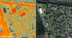
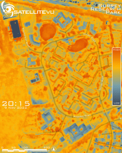
Pictured above is a comparison between Satellite Vu’s high resolution thermal image of Surrey Research Park, on the left, and Google’s optical image on the right. Below is a time series showing how the Park changes, possible providing pattern of life insights into the behaviour of the buildings.
EPC
The wider context for the partnership is also the estimation that 220 million buildings in Europe do not meet EPC (Energy Performance Certificates) regulations that will, in theory, be enforced in 2030.
“As governments and businesses model the road to Net Zero, satellite technology will be a critical asset due to its scalability and the comparability of the data,” said Anthony Baker, Founder & CEO, Satellite Vu. “Satellite data already contributes to 50% of all climate change metrics, and we believe our infrared data set will be game changing in monitoring how human infrastructure is affected.”
“We are hoping we can provide precise, repeatable and verifiable facts as to where the biggest decarbonisation impact can be made. Our project with Surrey Research Park represents a scalable solution to this issue; opening opportunities at every UK campus or industrial park, and providing a blueprint for housing associations and portfolio owners.”
Net zero
For its part, the CEO of Surrey Research Park, Grant Bourhill, added:
“We’re thrilled to be working with Satellite Vu. The benefits of their thermal satellite imaging technology are clear, and this project will support us in reaching our Net Zero aims by providing insight into the energy efficiency of our buildings, pinpointing where improvements need to be made and enabling us to plan our retrofit for optimum impact in the most time-efficient, cost-effective manner.”
See also: Satellite Vu turns to Orbit Logic for satellite imaging schedules
 Electronics Weekly Electronics Design & Components Tech News


